


snorbens_caleyman
-
Posts
2,061 -
Joined
-
Last visited
-
Days Won
40
Content Type
Profiles
Articles
Forums
Blogs
Gallery
Downloads
Store
Events
Posts posted by snorbens_caleyman
-
-
On 9/28/2020 at 5:38 PM, Robert said:
Good for them! Hopefully if they have decent bandwidth we will get a clear view of the action.
Could someone nip down to Station Park and put a shilling in the meter, please?
-
Woooo - yes!
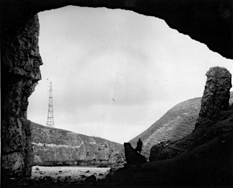
I vaguely remember him saying that that pylon was part of something like a radar station that was there at the time - it looks very like the old Chain Home antennae - and that he really shouldn't have included it in the photograph.
-
I hadn't put the name on it, so that someone else could have a go. Never mind...
Here's one my Dad's from 1954 or thereabouts.
-
-
Staggies Supporters' Club Away Day?
-
 1
1
-
-
Badbea clearances monument, Caithness.
-
 1
1
-
-
 Hang on, I'll just search Scotland using Google Earth. I might be some time...
-
The hills in the background suggested to me somewhere on the Moray Firth coast.
So I've just taken a quick trip along the coastlines with Google Earth, looking for that distinctive harbour layout.
It's Balintore.
-
2 hours ago, Yngwie said:
I wonder if any studies have been done yet on closed doors matches since football restarted to see if there has been any change in the split of home/away wins?
https://www.ft.com/content/0243c597-c32c-4cfa-8632-097e8393d229
Mid-July: "A FT analysis of Premier League matches played “behind closed doors” since games resumed last month suggests, if anything, home teams are performing better than before the pandemic".
Don't know if there is anything more recent.
-
2 hours ago, TheMantis said:
Portnahaven, Islay. A door each for the parishioners of Portnahaven and Port Wemyss. A Telford church.
I had no idea. But after your clue, I searched for "two doors", "church", "significant" and (I can't quite remember) probably "western isles".
Looked at the images returned, and there it was.
I had no idea that Telford had designed churches, so thank you for that!
-
59 minutes ago, TheMantis said:
The two doors are significant.
Thank you!
Two separate villages, apparently.
Whisky country.
And there is a connection to Caley - and I do mean just Caley. Though it's not unique to this church.
-
3 hours ago, TheMantis said:
Ben Stack from the East. Tricky one.
Well done - that's it! Ben Stack has a very distinctive outline, but nearly all photographs are taken from the north or north-west - which might make you think that I had reversed it, again.
But I found this one below, which is labelled "Ben Stack from Meallan Liath Beag", which is about 17km away SE of Ben Stack.
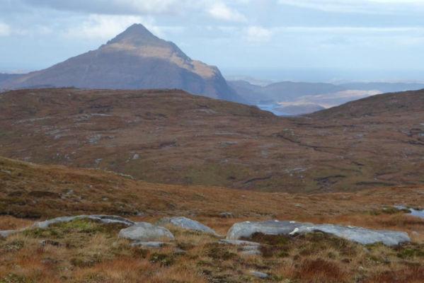
It's clear that my Dad was on almost the same bearing from Ben Stack. From the map, I realised that he was much closer, on the high ground to the SE of Loch na Mucnaich at the bottom right of the map below. The 719m peak of Ben Stack is at the top left.
On the shore of Lock Stack beside Airdachuilinn, above the centre of the map, is the house where my Dad's uncle and later his cousin stayed when they were head gamekeepers on the estate there. It's an area that he loved.
-
1 hour ago, Kingsmills said:
A 1.30pm kick off means that games could be played out in natural light over the Winter and we could save a few thousand pounds over the piece by not having to power up the floodlights.
Might get a few teams moaning about the early start they will have to make.
-
12 hours ago, TheMantis said:
Do you know this one yourself or are you looking for help again

I am 99+% sure of it. Most modern photographs of this place are from a different angle, but I'm sure that this one this time isn't reversed, if that's what you're getting at

Because a) I have seen some modern photos from the same angle, and b) it's from a print, not a transparency. I have also worked out where my father took it from, and it makes sense to me.
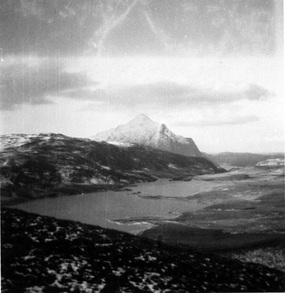
10 hours ago, IBM said:I am not a mountain man
 Has this loch got a dam at one end and an inn at the other?
Not that I can see from the map. Haven't been that way myself for a while.
-
OK, mountain men, here's one of my Dad's photographs, from 1947. Though I don't think it has changed much...
Interesting damage at the top - almost mirrors the mountain.
-
25 minutes ago, Alan Simpson said:
Kim Jong nics taking home a whore of a pay packet bigger than boris's!
What's your source? A minute's research tells me that they are about the same.
-
3 hours ago, Yngwie said:
Sturgeon has now said that the phased return of fans from October is “unlikely”.
I find this slightly odd, given that watching a football match is an outdoor activity, and the current thinking is that the risk of passing on the virus outdoors is low.
I would have thought that a well-supervised and socially-distanced crowd - which might simply mean spreading out a normal crowd for the Championship and League 1&2 clubs - should be OK. Especially if they are self-policing as well - i.e. calling out anyone who is being stupid.
Doofer's Dad posted his message above whilst I was typing this, but I thought I'd give you my tuppence-worth anyway.
-
1
-
-
39 minutes ago, weeman said:
Also did you know it's named after a nephew of St. Columba??
Jemimaville!
-
2
-
-
From that photo, plus the references to Strathconon and Balnaguie on a gravestone in the previous pic, I'd guess that we are on the Black Isle.
Where there are many, many churches
-
Ha! A giveaway.
"A concrete barge, the Cretetree is beached in the harbour of the Isle of Scalpay near Tarbert, Harris, Scotland. She was built by Aberdeen Concrete Ships, and completed in 1919."
https://en.wikipedia.org/wiki/Concrete_ship#Europe
Explains why I couldn't get Portree or Tiree out of the letters that I made out
-
1
-
-
Can't quite make out the name of the boat, if that's what you are referring to.
Can make out some letters, but they don't make sense to me. Enhancing with edge detector filters doesn't help.
Only one of its kind that you have seen. A whaler?
-
On 9/5/2020 at 9:54 PM, IBM said:
Here is an old one have you ever seen this boat?
Looks like no one has
-
1
-
-
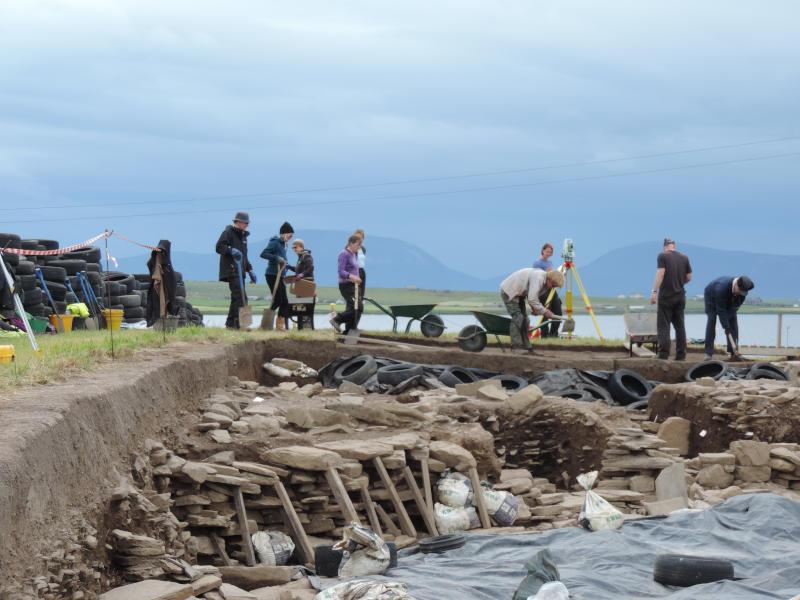
And, though I am sure that you know, my photograph is of the archeological site at the Ness of Brodgar.
One of the most important archaeological sites in Europe, if not the world. And it receives no government funding. Criminal.
In a normal year it's only open for the three summer months, when the academics and students are "on holiday". And this year it didn't open at all.
-
12 hours ago, IBM said:
See how the others get on with it.
Never actually been to that precise spot. But the topography is pretty distinctive, and, using the coastline, I went more or less straight to it on Google Earth. Then confirmed the name of the hill.
It got me thinking that the hill might appear in the background of some of my own photographs. Having looked at some online photos of the hill, and checked the direction on Google Earth, I am fairly sure that that's it in the photograph below, behind the people just left of centre.
No work done on that site this year - another consequence of the pandemic


And so it begins.....
in Caley Thistle
Posted · Edited by snorbens_caleyman
Thanks! But could you tell them that moving pictures have been invented?