snorbens_caleyman
+05: Player Sponsor-
Posts
2,061 -
Joined
-
Last visited
-
Days Won
40
Content Type
Profiles
Articles
Forums
Blogs
Gallery
Downloads
Store
Events
Everything posted by snorbens_caleyman
-
Terrific. Run after the ball and leave an attacker on his own just outside the 6-yard box. Get a grip, FFS.
-
The solution I outlined above is working for me. I'd have thought it would work for you, too.
-
You're right, but this is the first time that I have encountered anyone actually enforcing the rule. I have just downloaded ProtonVPN - https://protonvpn.com/about - and the outside world now thinks I am in Amsterdam, and Raith are allowing me to buy a ticket. I'll give it a go - all I can lose is the £14 for the PPV pass, and the only downside is that I'll have to watch the match on my computer, and not the TV. In case anyone wants to try it, ProtonVPN (and ProtonMail) came out of a project that started at the CERN labs. The idea was to provide safe and secure comms for journalists and activists. The bottom line is that I trust them. You need to set up an account with them - I already had one, because I use ProtonMail. I am going to try using the free version of ProtoVPN. The VPN encrypts your comms, and also routes your traffic so that it emerges onto the internet from one of their servers. The free version allows you to choose between the Netherlands, Japan, and the USA, so naturally I chose the Netherlands. The next version - "basic" - has many more options and costs 4 euro a month, so if the free version doesn't work, I may try that. You simply download and install the VPN software, then start it up. You have to login, and then specifiy which of their servers you want to connect to. After that, all your comms are routed through their network. I have checked with some of the "what information am I leaking?" sites that I really do appear to be in Amsterdam. I have also checked email and web browsing, and all looks OK. It took less time to install and run it than it took me to write this mail. Fingers crossed!
-
Raith won't let me buy a PPV pass, because I am in England Might be time to look for a VPN. Anyone recommend a reliable and safe one?
-
No Panic over the Bridge Caption Competition
snorbens_caleyman replied to CELTIC1CALEY3's topic in General Football
"FFS, at this rate I'll be back at Queens Park next season. We'll be playing them!" (Queen's Park are currently top of League One. Wikipedia: "Mackay's father (also named Malky Mackay) is a former footballer who played as a striker. The Mackay family are all supporters of Glasgow-based club Queen's Park. Mackay Sr. is a member of the board at the club. Mackay Jr. played for amateur side Queen's Park as a teenager, whilst working in a branch of the Bank of Scotland.") -
Why is the restart being delayed? Hope it is nothing to do with the injuries at the end of the first half.
- 37 replies
-
- spfl
- championship
-
(and 3 more)
Tagged with:
-
Now that I definitely agree with!
- 37 replies
-
- borough briggs
- elgin city
-
(and 2 more)
Tagged with:
-
I don't think so We controlled most of the game. Elgin scored with the first two chances that they had, and even then I wasn't worried. We were getting into their box with ease, but then screwing things up. I was reminded of my comments from last week, saying that we made plenty of chances but couldn't finish. Then Mckay popped up to level things before half-time, and the second half was going to go only one way. I predicted 4 or 5 - we certainly should have had at least 5. I think Duku has had a fair run to prove himself, but it's time to suggest that he starts looking elsewhere. He made a mess of his scoring chance, and otherwise was, as usual, coming off second-best in tussles in non-dangerous positions towards one side of the pitch. He tries, but he is just not effective.
- 37 replies
-
- 1
-

-
- borough briggs
- elgin city
-
(and 2 more)
Tagged with:
-
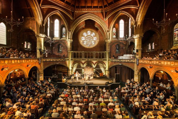
Going to my first live show since Feb 2020 tonight. The wonderful Caravan (ask yer granda) playing at the lovely Union Chapel in Islington. Definitely "classic music", and led, as always, by Tomintoul resident Pye Hastings. Will still be a bit strange, because there will be no bar or refreshments on sale. The venue emphasises the government guidance on wearing face coverings, and a recent review of another gig there said that most people were doing so. Given the age of a Caravan audience, I expect most people will be wearing them tonight. Details of new album and link to first single here: https://www.progradar.org/index.php/2021/09/21/caravan-release-if-i-was-to-fly-the-first-new-single-and-animated-video-from-its-none-of-your-business-their-new-studio-album-out-on-8th-october/ Going to see the Peatbog Faeries later this month, in a much smaller venue, where the crowd will be a fair bit livelier than a Caravan crowd. Looking forward to it, but with a little bit of nervousness. Then next year, we have four shows postponed - sometimes more than once - from 2020. Fingers crossed.
-
If Doran is one of the three, then, sadly, I don't think that he is a key player any more. Devine and Carson, yes. Your point is valid, and, yes, we conceded two goals, but I think the main problem was at the other end of the pitch. We made enough chances to win the game. We just have no one who can reliably get shots or headers on target, and thus put the ball in the net.
- 67 replies
-
- spfl
- new douglas park hamilton
-
(and 3 more)
Tagged with:
-
Don't see why coming on as a sub makes any difference. Unless he needs 60 minutes to warm up....
- 67 replies
-
- spfl
- new douglas park hamilton
-
(and 3 more)
Tagged with:
-
Agreed. I was thinking that the next few games - maybe up until the end of the year - could be sink or swim. We still have the problem that has existed since Billy Mckay left for the first time - we have no reliable goalscorer. Duku is ineffectual, Sutherland lacks ball-control skills, and Mckay himself never seems to get near the ball. Blue-skies thinking - when Carson is fit again, I would be tempted to see just how far forward he can play. Start him in midfield again, and then see if he can play higher up the park.
- 67 replies
-
- 1
-

-
- spfl
- new douglas park hamilton
-
(and 3 more)
Tagged with:
-
You got that right! Care to predict 3 goals for us now?
- 67 replies
-
- spfl
- new douglas park hamilton
-
(and 3 more)
Tagged with:
-
2 down. Toothless, leaderless, clueless, hopeless.
- 67 replies
-
- spfl
- new douglas park hamilton
-
(and 3 more)
Tagged with:
-
Sound now, but only on the right-hand channel. It's not your system
- 67 replies
-
- spfl
- new douglas park hamilton
-
(and 3 more)
Tagged with:
-
There was sound on an ad a few minutes ago. Wildly swinging camera eventually settling on the ball suggests Pixellot to me
- 67 replies
-
- 1
-

-
- spfl
- new douglas park hamilton
-
(and 3 more)
Tagged with:
-
-
That's my birthday night sorted, then
-
Inverness CT -V- Queen of the South - Preview
snorbens_caleyman replied to Robert's topic in Caley Thistle
I will be hearing all about it soon I'm in Falkirk and shortly to meet up with my wife's relatives. Cut them, and they bleed Warriors' blood.- 52 replies
-
- spfl
- caledonian stadium
-
(and 3 more)
Tagged with:
-
Agree that it looks good, but y/e May 2020 takes us only into the start of the pandemic.
-
Caley and Thistle 6 Tottenham Hotspur 3
snorbens_caleyman replied to Kingsmills's topic in Caley Thistle
Alex Main's book "Caley All The Way" just mentions it in passing, as does Bill McAllister's "Highland Hundred". Though Bill does say that there was a rumour that the Wembley winners "were more relaxed than they might have been" by the time they reached Inverness. The Select team was: J Sutherland (Thistle); A Sutherland (Thistle), Mitchell (Caley); J Fraser (Caley), D Fraser (Caley), R Fraser (Thistle); Docherty (Caley), Robertson (Caley), Macdonald (Thistle), Mackenzie (Thistle), Lamb (Thistle). I love the half-back line of three Frasers! Scorers were Macdonald (2), Lamb (2), Mackenzie and Robertson. -
That was a good game not to lose. Dunfermline were obviously determined not to lose, and were cynical in doing so. Can't remember when I last saw a team commit so many fouls. The referee was weak. The commentators were biassed idiots. They were surprised when Sutherland went off - it was because he had just been hacked down, you morons. I turned them off in the second half, after my wife booked me for swearing. Duku tries, but he is just not effective. And Billy will never score unless there is good service into the box. Thanks go to Ridgers for keeping us in the game. Mark that one down as experience, get the video analyst on the job (did I say the TV picture was rubbish?), and back to winning next week.
- 39 replies
-
- 2
-

-
- spfl
- championship
-
(and 3 more)
Tagged with:
-
Top of the table clash: Partick Thistle (H): 11 September
snorbens_caleyman replied to Robert's topic in Caley Thistle
OK, I give up. Why does the number 4 have so much meaning to DAFC fans? (The only thing I can think of is that most holes on a golf course are par 4s. ) -
Top of the table clash: Partick Thistle (H): 11 September
snorbens_caleyman replied to Robert's topic in Caley Thistle
It did indeed make me curious about how much anti-doping testing takes place in the Championship! -
Top of the table clash: Partick Thistle (H): 11 September
snorbens_caleyman replied to Robert's topic in Caley Thistle
Amazing turnaround in the second half. Billy Dodds must have been very eloquent at half-time. Did anyone see what happened in about the 80th minute when Graham and Carson clashed off the ball in front of the main stand? The TV missed it.


